A Newlyn Retrospect
Where is
Church Lane?
 What
we now know as Gwavas lane was until the end of the 19th century known as
Church Lane. This was because Paul Church was the Parish Church for Newlyn Town
until1866 when St Peters Church was built. For hundreds of years baptisms,
marriages and funerals took place at Paul with the walk up the hill that
this entailed.
What
we now know as Gwavas lane was until the end of the 19th century known as
Church Lane. This was because Paul Church was the Parish Church for Newlyn Town
until1866 when St Peters Church was built. For hundreds of years baptisms,
marriages and funerals took place at Paul with the walk up the hill that
this entailed.
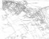
Click
on the 1881 map and you will see Park-an-Grouse This joined
the Bowjey (Cow House), a piece of
common land used by the fishermen for drying nets. Park-an-Grouse stands
for Field of the Cross in Cornish. As a Cross was used to mark a resting places
along the road to the Church. A footpath ran on the Mousehole side of the
field and worked its way up the hill to join what we now know as Gwavas Lane.
The
cross has been missing from the field for a long time but it was reported in the
1940's that the base was in the garden of a house at the top of the field and I
can certainly remember it being there as a child.
I wonder if anyone knows its whereabouts today?
Sandra
M Vingoe.
Newlyn Notes
Questions or problems
regarding this web site should be directed to the Web master.
george@penhalvean.freeserve.co.uk
e-mail the Morrab Web Master
Morrab Libary. Copyright © 2001. All
rights reserved.
Revised: January 31, 2002